Gigabyte-Scale GIS. 100% Offline.
GIS Without Limits
Render multi-gigabyte vector and raster datasets directly on your Android device. VectoTrail provides zero cloud dependencies, zero latency, and absolute data ownership for demanding field operations.
No Cloud Required
Drop PDF, GPKG, Shapefiles, MBTiles, and GeoTIFFs directly onto local storage. Our battery-optimized rendering engine handles heavy geospatial layers natively without throttling your hardware or draining your field battery.
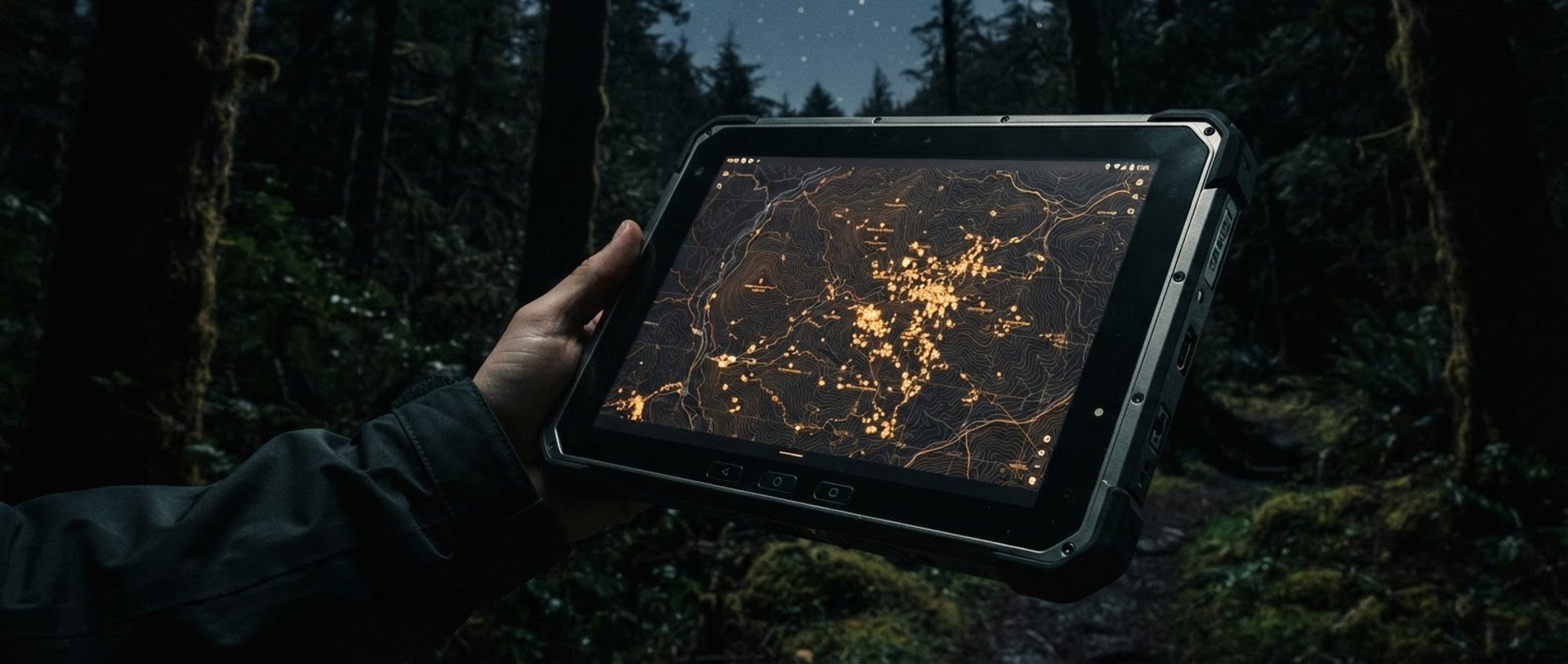
Load heavy datasets
Built for enterprise-scale geospatial workloads. Benchmark testing on a Samsung Galaxy S24 successfully loaded a single project containing more than 5 GB of geospatial data, including a vector GeoPackage exceeding 3 GB and a GeoTIFF raster larger than 2 GB. Initial data preparation ran entirely in the background, allowing the device to remain fully responsive for other activities throughout the process. Once loaded, the application delivered smooth map navigation and visualization with no software-imposed size restrictions.
Engineered for Demanding Fieldwork
VectoTrail processes heavy geospatial formats locally on your Android device. Zero cloud dependency means your maps render instantly, even fifty miles past the nearest cellular network connection.
Native Format Support
Battery-Optimized GPS
Custom Field Forms
Load PDF, GPKG, SHP, MBTiles, GeoTIFF, GeoJson, CSV datasets directly. No cloud conversion or proprietary server pipelines required.
Capture high-accuracy tracks and capture geotagged photos. Our background tracking algorithm is engineered to minimize battery drain in remote areas.
Build structured data collection templates with validation fields and offline media attachments to standardize your team's field operations.
On-Device AES-256 Encryption
Zero Cloud Dependency
Protect sensitive environmental and infrastructure data. VectoTrail secures all local databases using AES-256 encryption, ensuring your field data remains private and entirely under your control.
Your data never touches third-party servers. Licensing, storage, and rendering happen completely locally on your hardware. We do not track, store, or monetize your geospatial assets.
The Core Agreements
1. Perpetual Lifetime License
Each one-time purchase grants a non-exclusive, perpetual license to run the application on authorized personal or enterprise devices. No recurring fees apply.
Absolute Privacy
VectoTrail does not operate servers, collect telemetry, or transmit your geospatial files. Your local hardware is the sole vault.
2. Complete Data Ownership
All imported geospatial files, tracks, and custom forms remain your exclusive property. We cannot access, decrypt, or recover your local database.
3. Local Security Mandate
You hold sole responsibility for managing your AES-256 encryption keys and maintaining secure device backups. Lost keys cannot be recovered.
4. Liability & Performance
The software is provided as-is for offline operations. While optimized for demanding field environments, users must verify critical coordinates independently.
Own Your Field Data
Acquire a lifetime license with a single one-time purchase. Secure absolute operational freedom with zero recurring subscription fees, zero forced cloud synchronization, and complete data ownership forever.
VectoTrail
Professional offline GIS.
Gigabyte-Scale. 100% Offline.
SYSTEM
Home
Features
Industries
Terms
FIELD SUPPORT
support@vectotrail.com
Offline licensing & volume deployment inquiries
Built for Android devices
© 2026 VectoTrail-Engineered for demanding field operations.
LOCAL DATA • ZERO SUBSCRIPTIONS